Cartography in Ottoman times
NIKI GAMM

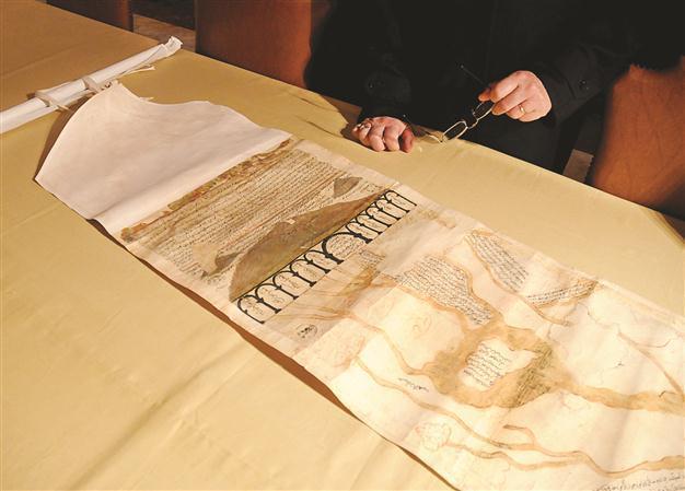
Recently, a map attributed to Ottoman traveler Evliya Çelebi was uncovered in the Vatican Library and depicted the Nile River and Egypt in
the 17th century.
Finding a map today is easy, with or without a computer. This was not necessarily so in Ottoman times. The need to be able to navigate the seas was critical for sailors but, despite a long tradition of astronomy and seafaring, the early Ottomans would have had to go some way to find an accurate map.
The Samarkand School of Geography and Astronomy produced many classic scientific works on the subject of mapmaking during the Middle Ages, and these had a profound effect on the Ottomans. At the same time, maps produced in the
West were available, and the Ottomans readily incorporated this geographical information into their maps.
Among first great maps
Piri Reis drew one of the first great maps of the Ottoman Empire and presented it to Sultan Selim II in Egypt in 1517; this map, a section of a larger one, showed parts of the American continents, as well as Europe and Africa. Reis himself writes he based the map on 34 others. In his book “
Kitab-ı Bahriye” (
Book of the Sea), the maps he included demonstrate significant detail. He illustrates ships and cities in the Mediterranean and Aegean Sea coasts, as well as providing information relating to maritime issues. Reis later developed a second world map that he gave to Kanuni Suleyman in 1528.
Matrakçı Nasuh (1480-1564) was arguably the next great Ottoman mapmaker, although his method of portraying cities in the Mediterranean was quite different from Reis. Undoubtedly their varying backgrounds had a significant impact on their work. While Reis was a sailor who rose to command within the Ottomans’ Red Sea fleet, Matrakçı was raised in the Palace School and was a historian, mathematician and miniature painter. We have him to thank for the quite extraordinary and well-known miniature map of Istanbul drawn in 1540. We also owe him for his depiction of Toulon, France, while the Ottoman fleet was anchored there in the winter of 1543.
The 17th century travel writer
Evliya Çelebi (1611-1682) wrote in the first chapter of his “Seyahatname” (Travel Book) there were 15 cartographers working in eight different places in Istanbul. They typically knew several languages, including Latin. These maps incorporated material from Europe and were principally prepared for sailors to use. Interestingly, probably because of the language, the information did not flow west and Ottoman maps did not make their way to Europe.
Recently, a map attributed to Evliya Çelebi was uncovered in the Vatican Library and depicted the Nile River and Egypt in the 17th century. It is likely a cartographer actually drew the map based on Çelebi’s explorations in that area.
Another of the most famous geographers of the Ottoman era was Katib Çelebi (1609-1657) for his work “Cihannuma,” which is a book relating the geography of the world. Although it followed a rather classical division of the world into spheres, elements and climes, he added the idea of illustrating it with maps and including information based on Europe and the New World.
Thanks to a translator, Katib Çelebi had access to a number of European manuscripts, including Mercator’s Atlas. This prompted him to abandon Islamic cosmography as an approach and present a more systematic geography with an overview of the seas and continents and a description of countries from
east to west. There were two versions in circulation but, given the incompleteness of the second version, it has been suggested he died before he had time to finish it.
‘Cihannuma’
When Ibrahim Müteferrika printed “Cihannuma” in 1732, it attracted a great deal of attention. At the request of Sultan Ahmed III, he translated Andreas Cellarius’ work on astronomy in 1733, in spite of the growing signs of discontent with the sultan’s rule.
It does, however, indicate there was general acceptance of scientific works by Europeans in the Ottoman Empire. As Professor Ekmeleddin Ihsanoğlu has pointed out in his various writings, the Ottomans had no problem fusing European science with earlier Islamic scientific work.