Mapping the Ottomans
Niki GAMM

Most of the Ottoman maps are hand-drawn, with the back sides covered in satin cloth.
Today, you just have to whip out your smart phone or a tablet, punch in some letters and numbers and you’ll know where you are immediately. You couldn’t do that in the Ottoman Empire of the Middle Ages, however. Paper was extremely expensive and knowledge was in scant supply. Navigation had to be carried out using observations of the sun / moon and stars and such instruments like the astrolabe, which weren’t so accurate.
The Samarkand Observatory in Uzbekistan produced many scientific studies on astronomy and influenced the work being done under the Ottomans. We are fortunate in having some maps drawn in the sixteenth century simply because they were presented to the sultans of the time and were preserved at Topkapı Palace. These are the maps of cities around the Mediterranean made by Piri Reis and Matrakçı Nasuh. [Matrakçı Nasuh is to be included on UNESCO’s 2014 commemoration agenda: see Hürriyet Daily News, 23/10/14.] Katib Çelebi included maps in his work Cihannuma, which he wrote in the middle of the seventeenth century.
Istanbul even had a group of cartographers working on producing maps for sailors in the seventeenth century, according to travel writer Evliya Çelebi. These maps, some of which relied on western maps, however are apparently lost.
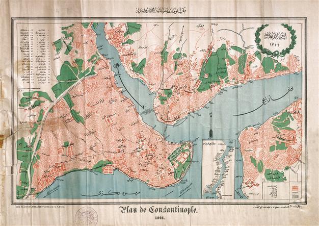
Later maps of IstanbulThe first modern map of Istanbul was drawn by a French engineer named Kauffer, who came to Istanbul in 1784 with French ambassador Comte de Choiseul-Gouffier as his secretary. He had been in the city earlier and made drawings, but now he had a chance to correct these. In 1786, he and another engineer prepared the first plan of Istanbul. A copy of the plans was sent to Choiseul-Gouffier, who had escaped to Russia following the French Revolution, and a copy remained in Istanbul. These plans were published in 1819 with the detailed additions that Barbie du Bocage made in Antoine Ignace Melling’s book entitled “Voyages Pittoresque de Constantinople et du Rives du Bosphore” on a scale of nearly 1/100,000. They are the most important documents that ensure our learning of the characteristics of Istanbul and Bosphorus settlements at the beginning of the nineteenth century. One of the Kauffer maps includes the Old City and the Bosphorus, while a second one covers part of the Black Sea and the Anatolian shore.
The first urban plan the Ottoman State had drawn was made by the German soldier Helmuth von Moltke, who had been sent in 1835 by the Prussian government to serve as an advisor to the Ottoman army. He was stationed with the Ottoman army for four years. He published his maps in 1840 after he returned to Germany.
Maps, plans from Sultan Abdülhamid II’s reign
Sultan Abdülhamid II (r. Aug. 31, 1876 – April, 27 1909) is someone remembered for his paranoia and his oppression of revolts against his rule. But there were other sides as well, such as his talent for making furniture in line with the dictum in the imperial family that males should have a skill, with which to feed themselves should they have to one day. There was his love for the theater and opera, perhaps acquired when he traveled in Europe as a young man.
Once Abdülhamid II became sultan, however, he was unable to travel, so he commissioned photographers to take pictures of the most important elements in cities around the Ottoman Empire. He collected these in albums that today are located at Yıldız Palace and in the Istanbul University Library. He also had an interest in photos of important people around the world, including heads of state in Europe and even U.S. President Abraham Lincoln. He even had a photograph of the moon, which was an extremely difficult shot, given the state of photography at the time. [See “Sultan II. Abdülhamid Arşivinden Dünya Liderleri,” published in 2011 by the Istanbul Metropolitan Municipality’s Culture, Inc.]
Yet another side to this sultan was his little known interest in maps and city plans and especially what the city of Istanbul looked like in the nineteenth century. The newly published “Sultan II. Abdülhamid Devri Harita ve Planlarında Istanbul” for the first time brings together 150 maps and plans from the time of Sultan Abdülhamid II. It includes maps and plans prepared at the command of the sultan, as well as maps related to the padişah’s possessions in Istanbul and the surrounding area, building activities, drawings of bridges and official offices, military buildings and the population. The book has drawn on Sultan Abdülhamid II’s Yıldız Palace Collection and reveals a side of the padişah that isn’t well-known, and through which, he followed Istanbul and its surroundings through maps.
According to the information in the book, Abdülhamid II closely followed developments throughout the Empire with the large photograph albums that he had taken, and at the same time, he gathered information about Istanbul and its environs in district after district with maps. The padişah’s interest wasn’t just limited to Istanbul. The atlas includes the Ottoman cities that are in the book is dated 1308/1891. The atlas is made up of 24 maps on pasteboard, colored and hand-drawn is 76x122 cm.
Handdrawn maps
Most of the maps are hand-drawn. The back sides of the maps were covered in satin cloth. The oldest map found in the book is clearly a working map in tan and grey. Drawn for the benefit of Sultan Selim III just prior to his being dethroned, it is dated 1806-1807 and shows the location of the various cannons that had been built in Istanbul for defensive purposes and the range that the cannons could reach. The area in which the guns were collected is unsurprisingly at the place where the Sea of Marmara meets the Golden Horn and the Bosphorus. The map, a product of the geometry school, is hand-drawn and 82x92 cm in dimension.
The most recent dated map in the work is dated 1902 and is an Alibeyköy farm near Küçükçekmece. It is 134x190cm, hand-drawn, colored, cloth on pasteboard. The maps that were the most important were measures to be taken in case of need. The significance of the maps that Abdülhamid II collected was strategic; they were to be used by the military in case of defense. To that end, the most modern technology was used.
The plans include reservoirs, buildings and gun emplacements. Altogether, the book contains 150 maps and plans show us how far cartography had come at the beginning of the twentieth century.
“Sultan II. Abdülhamid Devri Harita ve Planlarında Istanbul” is available at bookstores.