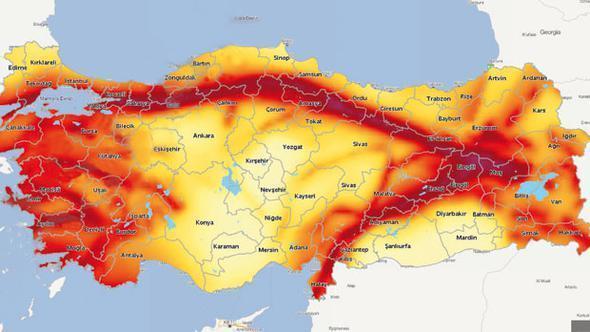
Turkey’s official “earthquake map,” updated with the efforts of five universities and two state institutions for the first time in 21 years, is expected to be presented to the council of ministers on Jan. 1, 2018.
Construction companies are obliged to take the earthquake map - which highlights quake hazard zones nationwide - into account, calculating seismic loads accordingly in order to build quake-resistant structures.
Prof. Dr. Ahmet Ercan, a prominent geophysicist, told Hürriyet that 80 percent of the renewed map matched the previous map. However, Ercan voiced skepticism about a number of the changes, particularly criticizing the inclusion of the seaside town of Kaş and the city of Antalya on the Mediterranean coast in a “risky region.”
“In addition Van, Erzurum, Elazığ, and Tunceli [all provinces in eastern Turkey] should be moved from the [seismological grade] scale of two to one, while the Kocaeli peninsula [in northwest Turkey] and Istanbul’s Anatolian side should not be first degree risk areas,” Ercan said.
“Istanbul’s European side has been updated from second degree risk to first degree risk and İzmir’s Çeşme peninsula has also been shown as a first degree risk area, but this is wrong,” he added.
Ercan also noted that despite the map showing the district of Bodrum in the southwestern province of Muğla as a risky area, some parts of Bodrum are “appropriate for settlement.”
The map was prepared through join cooperation between the Middle East Technical University (ODTÜ), Boğaziçi University, Akdeniz University, Çukurova University, Sakarya University, the General Directorate of Mineral Research and Exploration (MTA), and the Disaster and Emergency Management Presidency of Turkey (AFAD).
The map downgrades the seismic risk for Turkey’s capital Ankara from the previous map, while the downgrading of the eastern provinces of Van and Erzincan has raised eyebrows as these provinces were in recent years hit by severe earthquakes.
The most recent powerful quake that hit Van was in 2011 when a 7.2-magnitude tremor devastated parts of the province. More than 570 people were killed and thousands of structures in Van and other nearby towns were destroyed. The earthquake was felt as far away as Jordan and southern Russia.
Erzincan, meanwhile, was struck by a magnitude-6.7 quake in 1992. Originating on the North Anatolian Fault, the temblor left at least 498 people dead and around 2,000 injured. The most powerful earthquake that Turkey has ever seen was also in Erzincan, where a magnitude-7.8 quake killed an estimated 33,000 people in 1939.
Turkey is vulnerable to earthquakes because of its geographical location between two huge tectonic plates - Eurasia and Africa/Arabia - that inexorably grind into one another, north to south.


