Plateaus represent a passion that those who have not grown up with the smell of earth can hardly understand. For more than hundreds of years, these endless Anatolian lands lead our strangely familiar steps to the bosom of the mountains. Time stands still on the plateaus of the eastern Black Sea region until a sudden mist blurs your vision or a goshawk screams to attract you attention.
Welcoming the arrival of summer here feels like getting to know the most beautiful of Mother Nature. The eastern Black Sea region is known for its dark and stern sea and its plateaus painted in all shades of green. If you are really willing to hear the call of nature, we recommend you to read our suggestions regarding this colorful region. Amidst the most beautiful plateaus, wonders of nature, exciting activities, delicious breaks and undiscovered treasures, you will be accompanied with the constant feeling that this part of nature has a lot to offer.
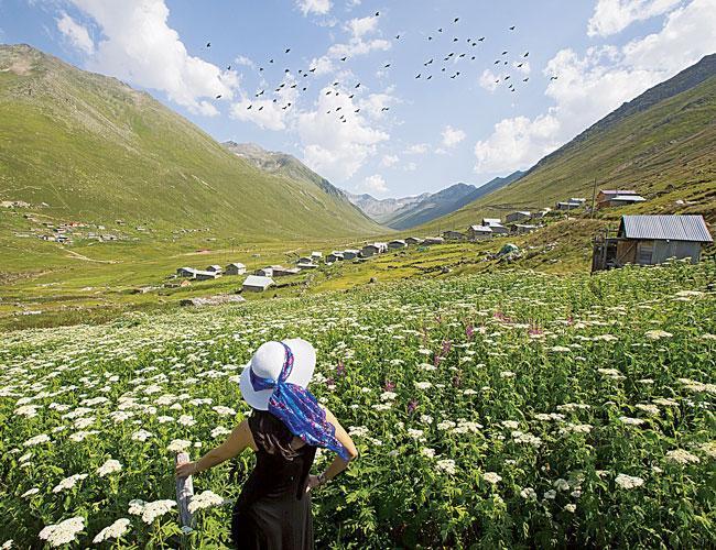
Closer to the stars
The road starts from İyidere on the shore of Rize and reaches the İkizdere Valley through the endless fields of tea and corn. The town called Güneyce is located on this road and is famous for its 150-year-old wooden mosques, which are made from scrupulously carved chestnut trees. The İkizdere Valley takes its name after the town with the same name, which is located where the brooks Köhçer and Cimil meet. The town is known for its colorful bazaar, Manle waterfalls and the Vane Thermal Spring. The town bazaar offers several items including maroon-colored, hand-loomed, ornamented headscarves called “keşan,” loincloths, woolen socks, village cheese, wooden tubs and lecterns.
Dereköy, located on the south side of the town, is the entry point to the İkizdere Valleys. Aside from the Anzer Valley famous for its honey, the Çamlık, Puşula, Gökyayla, Cimil, Çiçekli, Mahura, Yatak, Buzlağan, Kaban and Vaşa Valleys are located here as well. It is a good idea to take the Çamlık Valley, where accommodation, food and touristic guide services are provided as a center due to its accessibility. The 2,600-meter-high Ovit Summit, one of the two mountain passes with the highest altitude, is crowned with a glacial lake called the Aygır (Stallion).
The Çamlıhemşin road passes through a fascinating green panorama. The Hemşin Basin, fed by the Fırtına (Storm) Brook, is one of the best locations where you can see the steep nature of the Black Sea region filled with valleys. The basin, around which around 50 plateaus and more than 70 mountain villages are located, is surrounded by the highest mountains of the eastern Black Sea region. The manner of settlement in the area is in the form of small misty mountains and consists of only a few households.
The real surprise of Çamlıhemşin is the Makrevis neighborhood, where the most spectacular houses of the Black Sea region are located. The newest of the 20 houses on the side of a forested and misty mountain is 150 years old. The buildings that reflect the perfect synthesis of cut stone and wood have an interior space full of antiques, ceramic stoves and rare glassworks and reflect the taste of valley inhabitants.
Completely different world
The journey over the clouds continues on the Çatköy-Verçenik route. This green valley is full of arch bridges, countryside restaurants, mysterious monasteries and mini-telphers that carry supplies to the houses climbing up to the plateaus at the heart of Kaçkar Mountains. Zilkale, which rises in the middle of a wild canyon in the depths of the Fırtına Valley, has a mysterious and romantic appearance. This is also the entrance of Kaçkar Mountains National Park. This park is a heavenly haven for more than 230 species of birds and 2,300 living beings of which 550 are endemic.
The Kaçkar Mountains are the most important living areas of the hook-horned mountain goat and the birch chicken in Anatolia. This is a perfect center of attraction for nature observers. As the mountain road gets steeper towards the Kaçkar, the landscape is covered with pine forests, wide fields and plateau flowers. The road is forked at Çatköy on the skirts of the Tatos (Wish) Mountain, the road on the left leads to Elevit, Trovit, Palavit, Amlakit, Kavron, Hazindağ and Samistal plateaus, whereas the road on the right leads to the Hisarcık, Çiçekli, Orta, Baş and Hacıvanak plateaus. On the skirts of Çatköy is the hidden Kito Plateau viewed from above the Fırtına Valley. There are no new buildings in Kito except for the old wooden plateau houses. Kito is home to Balıklı Lake with its many springs. This wild plateau lying on the shore of clouds will take you to a completely different world.
Time for ‘Horon’
Maçka, a district of Trabzon hidden on the skirts of the eastern Black Sea Mountains and surrounded by green forests, is full of surprises such as cool plateaus historic medieval monasteries, traditional food and colorful festivals. Coşandere, a brook flowing through the district, leads to the Sumela Monastery. The road gets better as it leads to the Zigana Valley and into the mountains. Hamsiköy, home to the Club Zigana Holiday Village with around 40 wooden mountain houses, is the place where one can find the biggest plateaus facilities in the eastern Black Sea region.
Among the characteristic Maçka plateaus are Uzungöl, Şolma, Lişer, Sera Lake, Mavura, Kiraz, Lapazan, Çakırgöl, Çatma, Oba, Düzköy, Karadağ, Hıdırnebi, Kuruçam and Sis Mountain. The Torul-Gümüşhane-Yayladere route leads us to the undiscovered treasures of the eastern Black Sea region. Through the Salmankeş Pass, we reach the most inaccessible spot in the region, the Yağmurdere Valley. A town called Dumanlı is located on the shore of the Yanbolu Brook. This town had once been called Santa, which was the center of seven Greek villages. These villages, which are located in a narrow valley with a breadth of 1800 meters, are full of beautiful monasteries that have still survived.
Of course, one should not forget, one of the well-known homes to eastern Black Sea festivals. Artvin, hidden behind the unspoiled natural beauty of the Kaçkar Mountains, is the eastern Black Sea region with its plateau festivals, Georgian churches and natural sporting facilities. Kafkasör Plateau, otherwise known as the “Green Umbrella,” is famous for its bull fights. The festival lasts for four days and starts in the last week of June.
The dimensions and isolated spots of the Georgian churches, located near the villages in the Çoruh Valley and some of which were built almost a thousand years ago, are quite impressive. The most spectacular churches are the Dörtkilise (Four Churches) near Tekkale village in the Yusufeli district, the Öşkvank Church in the Çamlıyamaç village and the İşhan Church in the İşhan village. Those who want to see the villages of Artvin where the traces of Georgian culture are still visible can visit the following valleys: Meydancık (İmerhev) in Şavşat, Muratlı (Maradit) and Camili (Macahel) in Borçka. The cool breeze in the evening on the eastern Black Sea plateaus brings with it sounds of the joyful “horon.” The tunes of traditional musical instruments like the kemençe (similar to fiddle) and the tulum (similar to bagpipe) played by the local people of the plateaus call every wanderer to the eastern Black Sea.
How to get there
The shortest way to start your tour of eastern Black Sea plateaus is by taking a flight to Trabzon. You can start with the plateaus of Trabzon and move on to those in Rize and Artvin.


