Turkish company develops chopper software for foggy weather conditions
Cengizhan Çatal ANKARA
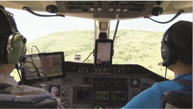
The software shows electricity poles and wires that are not visible to the naked eye when seen from the helicopter’s cockpit. Hürriyet Photo
An Ankara information technology company has developed software that allows helicopters to fly in foggy weather conditions.PiriReis Informatics Technologies, which operates at the Middle East Technical University (ODTÜ) techno-city in Ankara, has developed software enabling chopper captains to see the geographical obstacles in 3D on a screen even when visibility is close to zero.
The software is most remarkable for showing electricity poles and wires that are not visible to the naked eye when seen from the helicopter’s cockpit.
Gökhan Dağgez, an engineer working in the development of the software, said the standard systems in helicopters show only the horizontal and vertical situation, and the altitude of the chopper, whereas the newly developed software presents all the geographical obstacles in 3D format in every weather condition.
“Around the world, only U.S. and Israel are manufacturing these systems. We have developed this [system] all on national terms,” Dağgez said, adding that they had obtained the map details and locations of the electric wires from the relevant institutions.
The engineer said they had developed a warning system that alerted the captain 20 seconds prior to hitting an obstacle that was before the helicopter. The alarm’s audible and visual warnings become stronger once the chopper is 10 seconds away from the obstacle.
The systems main element was the GPS/INS device that sent the aircraft’s location to a computer via satellite.
“The software we developed collects this data [provided by the GPS/INS device] and the map details, processes it and warns the pilot,” Dağgez said.
The software is a complementary air navigation device that needs to be placed in all choppers. He said they had presented the details of the software to all the institutions that would need to use it.
Recalling helicopter accidents in Turkey due to thick fog, Dağgez said the software would come in handy when there is almost no visibility for flight.
“According to the investigations, the accident with the chopper carrying Muhsin Yazıcıoğlu occurred as a result of the plane hitting a mountain in foggy weather,” said Dağgez, also noting the latest helicopter accident in the northwestern province of Kocaeli that led to the death of four officers on Oct. 12.
The helicopter carrying the head of the Great Union Party (BBP), Muhsin Yazıcıoğlu, crashed in a mountainous region in the southern province of Kahramanmaraş while it was traveling from an election rally on March 25, 2009. All five passengers on the helicopter were found dead when the wreckage was located 47 hours later, including journalist İsmail Güneş, who called for help before succumbing to injuries he sustained in the accident.
“The system needs to also be used in firefighting aircraft that fly in thick smoke, as well as with ambulance helicopters,” Dağgez said.