Turkey’s cartographic history on display at museum
ANKARA – Anadolu Agency
AA photo
Turkey’s most prestigious cartographic museum is continuing to provide a fascinating look on the past with its trove of maps from Turkey and around the world.Operated within the body of the Defense Ministry’s General Command of Cartography, the Cartography Museum is home to maps from various periods and regions, as well as measuring and plotting apparatuses.
The most comprehensive museum in its field in Turkey, the Cartography Museum displays 559 artifacts as well as the personal belongings and works of Lt.-Gen. Mehmet Şevki Ölçer, the teacher of Turkey’s founding father, Mustafa Kemal Atatürk, and the founder of General Command of Cartography.
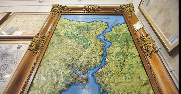
Hand-made relief maps, which are considered the first examples in the world and were made with sea sand, resin, wood and similar materials in the 1880s and 1890s, are among the most valuable artifacts in the museum.
Relief maps made by Military Academy teachers and students in various sizes show the critical regions of the era such as Edirne, Thessaloniki, Ruse, Preveza, Crete and Rhodes.
First example of modern cartography
The museum, which is home to historic paper maps produced since the 19th century, also displays a general map of the Ottoman state, including when the Ottomans had the widest borders.
A map of Eskişehir, which was produced in 1869, is considered the first example of modern Turkish cartography, while the Sakarya Map, which was created within 20 days during the War of Liberation and played a significant role in the victory over invaders from Greece, are other maps that draw attention in the museum.
Besides geodetic, photogrammetric and cartographic tools, the museum also displays other materials related to cartography.
A 114-piece set of compasses and water color, which was gifted to the museum by Sultan Abdulaziz’s son Yusuf İzzettin Efendi are also extremely valuable.
The museum also displays Ankara’s first city plan, made in 1924. This rare map shows public buildings, the Sıhhiye area, the Ankara Palas Hotel, the Hacı Bayram Mosque, Hamamönü, Ankara Castle, the Horse Bazaar and the Hacettepe neighborhood.
The first highways map made by the Turkish General Staff in 1893 and the Istanbul city plan, made in 1882, are also among the museum’s artifacts.
The one and only analogue plotting tool of the era used in map production is also on display in the museum. The tool, which was produced by Germany’s Carl & Zeiss Jena in 1939, is among the valuable pieces.
Turkey’s first aerial camera, which was brought to Turkey in 1934 and used to photograph the region from the air, is also in the museum.
Turkey’s first malaria map
Turkey’s first malaria map, which was produced for the Health Ministry, is also among the most important pieces in the museum. The map indicates the places where malaria was observed most predominantly, shading in the regions with marshes in red.
The museum also displays oil paintings made by famous painters of the era during the nationwide tours organized by Atatürk.
The museum, which is visited by nearly 5,000 people every year, is open to groups every weekday on condition of reservation, and to visitors every Tuesday and Thursday.