Professor reveals Evliya Çelebi’s unknown map
ISTANBUL - Anatolia News Agency
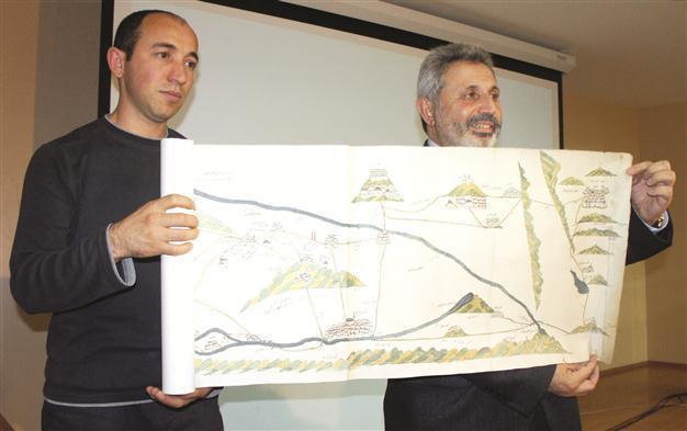
Professor Zekeriya Kurşun (R) shows press members Evliya çelebi’s map of the Tigris and Euphrates that he found after a long study process. The map starts from eastern Anatolia and reaches the Indian Ocean through the coastline of Tigris and Euphrates rivers, featuring castles, graveyards, tombs, bridges and roads. AA photo
An Istanbul professor announced the discovery of Ottoman official Evliya Çelebi’s map of the Tigris and the Euphrates on Dec. 21 to complement the traveler extraordinaire’s previously discovered chart of the Nile.Marmara University Faculty of Science Professor Zekeriya Kurşun held a press conference at the faculty, confirming the authenticity of the map, which charts the Tigris and Euphrates rivers.
“Our study shows the map belonged to Evliya Çelebi both physically and contextually. We have no doubt the map is from the 17th century in terms of paper, text and design,” he said.
Evliya Çelebi’s map of the Nile was mentioned in the 1950s and its existence was recognized in 2009. Now, Çelebi’s Tigris and Eurphrates map has been verified, according to Kurşun.
He said the map was found in William Trumbull’s (1639-1716) library, who served as the British ambassador to Istanbul in 17th century and in 1988 was auctioned by the Bernard Quaritch company, which was trading unique books and manuscripts in London.
After a lengthy study process, Kurşun found the map, which has an interesting story, he said. “Evliya Çelebi’s map, which starts from eastern Anatolia and reaches the Indian Ocean through the coastline of Tigris and Euphrates rivers, is colorful,” he said.
The 3.45-by-4.35-meter map features castles, graveyards, tombs, bridges and roads along the banks of the Tigris and Euphrates rivers to the Persian Gulf and the Indian Ocean, he said. “It has a unique quality and a similar kind of the map has not been made.”
Kurşun said the map, auctioned as a “unique Ottoman map from 17th century,” was bought by a Qatari collector, but it was not known who owned it formerly.
Texts date back to 17th century
Kurşun said he had seen the map in 1998 and worked on it since then. “When you look at the map, it is made up of eight conjoined parts. The text script on it dates back to the 17th century. There is no doubt about it,” he said, adding that mountains on the map were yellow-green and rivers were blue.
“This is a road map. Some parts of the map are red to highlight some places. It starts from the eastern province of Erzurum and follows the Tigris and Euphrates rivers to the north and south,” he said, adding that castles, mosques, bridges, tunnels, mansions and other landmarks were shown with drawings reflecting the features of its period.
Kurşun said the map did not provide information about its cartographer. “Our study shows the map directly indicates Evliya Çelebi,” he said, adding that its paper was from the 17th century, Çelebi’s period.
“Even though we have not carried out chemical analysis on the paper, the experts’ views and my experience show that there is no doubt about it. The map clearly shows that he drew those places after visiting there,” he said.
After his speech, Kurşun presented an exact copy of the map to press members.