Ancient Lycian road now has detailed map
ANTALYA – Anadolu Agency
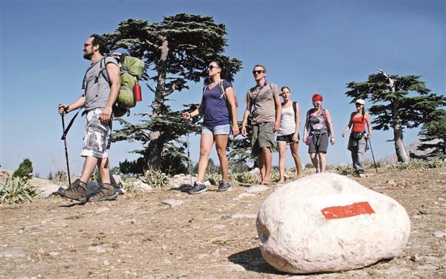
The Lycian road starts from the popular tourist town of Fethiye in the western province of Muğla and ends in the southern province of Antalya’s Hisarçandır village. AA Photo
Within the scope of the “Ancient Lycian Roads Map and Trekking Guide Project,” a detailed map of the Ancient Lycian Road has been drawn by the Antalya Governor’s Office and Culture and Tourism Directorate.The road starts from the popular tourist town of Fethiye in the western province of Muğla and ends in the southern province of Antalya’s Hisarçandır village.
The road was established by the Lycians in 2000 B.C. and later used by many other civilizations, including the Romans. The historic route has so far only been used by professional outdoor sportsmen, but the directorate hopes it will now regain its former glory. The facilities, trekking routes and paths to the mountain are marked one by one in the map, which will allow tourists and nature lovers to travel on the route easily.
Culture and Tourism Provincial Director İbrahim Acar said the Teke peninsula was named Lycia in history, and the coastal cities were all connected through the roads of the time. With the project, he said the paths between the Lycian cities had been marked and the Ancient Lycian Road had come to light again.
Acar described the map, which has been approved by the Defense Ministry and the Tourism Ministry, as “a first of its kind,” adding that the main purpose of the project was to promote cultural values in rural areas as an alternative to coastal tourism. “With this map, visitors will be able to see the mountains easily by following the route,” he said.
“Besides cultural promotion, people living on the route of the ancient road will have chance to sell their natural products like milk, yoghurt, molasses to trekkers and contribute to their budget,” he added.
Some 8,000 copies of the maps and guide books have been published in the first stage and delivered to district administrations, municipalities and tourism centers.
“The maps give information on accommodation places, transport opportunities, archaeological inventory, cisterns, geographical information and some practical information. The books that are given with the map provided information about the roads that once connected the ancient Lycian cities to each other,” Acar said.
Goal is 100,000 visitors in 2015
For the preparation of the maps and books, views were exchanged with the world leading outdoor sports organizers, and the end product is available in four languages: English, German, Russian and Turkish.
In 2015, the goal is for 100,000 mountain and outdoor sportsmen to use the road, Acar said, “as a first step.”
“Within the scope of the route, local and foreign tourists may send requests to the email address antalya@kulturturizm.gov.tr,” he added.
More details can be found via www.likyayolu.gov.tr and www.lycianway.gov.tr.