Centuries-old maps on display at Istanbul's Topkapı Palace with new exhibit
ISTANBUL - Hürriyet Daily News

The exhibition ‘Before an After Piri Reis: Maps in Topkapı’ displays for the first time 63 maps of eastern and western origin as well as unique Ottoman works together under a different theme.
Eastern and western maps, geography books as well as unique Ottoman works have been assembled for a new exhibition at Istanbul’s Topkapı Palace. Titled “Before and After Piri Reis: Maps in Topkapı,” the exhibition brings together works that paved the way for the Ottoman geographers and cartographers and is open at the Has Ahırlar section of the palace.Organized in collaboration with the Topkapı Palace Directorate and sponsored by the Bilkent Cultural Initiative (BKG), the exhibition displays for the first time 63 maps of eastern and western origin as well as unique Ottoman works together under a different theme.
 Speaking about the exhibition, Topkapı Palace Museum Director Professor Haluk Dursun said, “The museum’s depots have more works than the ones on display. Such special exhibitions bring these works to light and present them to audiences. After the exhibition of Sultan II Bayezid on the 500th anniversary of his death, the Chinese Treasures Exhibition and the Piri Reis Exhibition, Topkapı Palace presents one more part of our significant works to visitors in this latest show.”
 Orhan Hallik, executive board member of Bilintur, which includes BKG, said that the exhibition was one of the special projects organized especially for the Piri Reis year, adding, “This is a social responsibility project for BKG, which we have made a brand.”
An exhibition in three parts
The exhibition consists of three different parts. The first part of the exhibition includes the works of Ottoman geographers and books and maps from eastern and western sources. In this part there are a total of 42 works from the 14th to 19th century.
The second part of the exhibition includes war plans and maps and there are total of seven works at this section. This is the first time that the plans are opening to an audience. The plans are part of the palace collection archives.
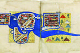
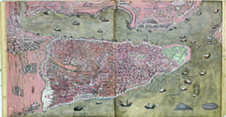 The third part includes 13 works and includes many works from Pîrî Reis’ Kitâb-ı Bahriyye and Alanya’s description and Ottoman artists Matrakçı Nasuh’s works and 16th century topographic works. Kitab-ı Bahriye (Book of Navigation), made between 1521 and 1525, is one of the most famous pre-modern books of navigation, including a world map. Although Piri Reis was not an explorer and never sailed to the Atlantic, he compiled over twenty maps of Arab, Spanish, Portuguese, Chinese, Indian and older Greek origins into a comprehensive representation of the known world of his era. The work included the recently explored shores of both the African and American continents.
 The book was translated into Turkish upon the order of Mehmed II. Apart from the maps, the book also contained detailed information on the major ports, bays, gulfs, capes, peninsulas, islands, straits and ideal shelters of the Mediterranean Sea, as well as techniques of navigation and navigation-related information on astronomy, together with information about the local people of each country and city and the curious aspects of their culture.
The exhibition features a total of 63 works, and a total of 18 geography books, including a 14th century copy by Ptolemaios and a very rare copy of Berlinghieri’s book in Italian which was prepared for Fatih Sultan Mehmed and presented to Bayezid II.
The exhibition also includes a copy of Janszoon Blæu’s Atlas Major, which was prepared on the order of Mehmed IV. There are four atlases from Ali Macar Reis Atlas books, along with rare Istanbul plans and maps, three water road maps, 13 of Piri Reis’s exclusive and rare maps, nine maps from Ottoman history books and topographic paintings. The exhibition ends on May 20.